UK Braces for Thunderstorms and Rare October Snowfall as Temperatures Plunge to -3°C
October 7, 2024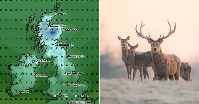
The Met Office has issued a warning for unsettled weather conditions across the UK, driven by an Atlantic low pressure system affecting the region from early October.
Before the anticipated cold snap, southern England and Wales are under a thunderstorm warning, with heavy rain expected.
Forecasters predict that some areas may receive between 20 to 40mm of rain in a short period, particularly along coastal districts.
A significant cold snap is forecasted to hit the UK starting October 11, bringing sub-zero temperatures lasting until October 14.
Temperatures during this cold snap are expected to drop as low as -3°C, particularly affecting northern regions.
Iverness is predicted to be the coldest location, with temperatures potentially hitting -3°C.
Northern areas, including Newcastle and parts of Scotland such as Edinburgh and Aberdeen, will experience the harshest conditions.
Heavy and persistent snowfall is predicted to blanket parts of the UK, with forecasts indicating it could last for up to 72 hours.
The Lake District and Pennines are expected to see the heaviest snowfall during this cold snap.
Snowfall is also expected in Wales, Birmingham, the Cotswolds, and Southampton from October 11 into October 12.
Following the cold snap, forecasts indicate a colder interlude with potential overnight frost and mist continuing into the weekend.
Later in the weekend, conditions are expected to become unsettled again, with rain and stronger winds returning to the northwest.
Summary based on 2 sources
Get a daily email with more UK News stories
Sources
The Mirror • Oct 5, 2024
Weather map shows four-day freeze set to blast Brits with icy temperatures
The Mirror • Oct 7, 2024
UK weather maps reveal exact date temperatures drop to -1C - and it's days away