Balancing Growth and Ecology: PRDUA's Path to Sustainable Urbanization and Carbon Neutrality
October 15, 2024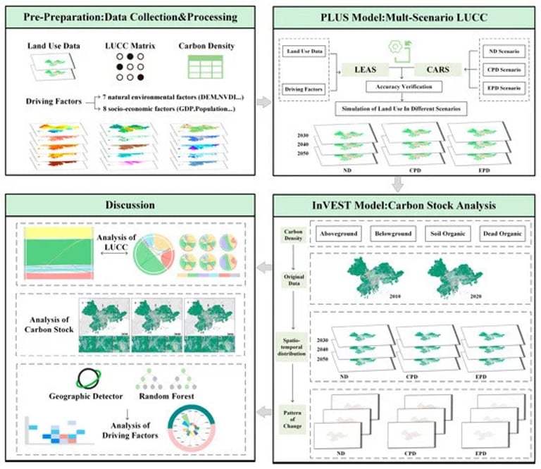
Research indicates that ecosystem service value (ESV) in the PRD has shown a fluctuating decreasing trend, while the economy has experienced a fluctuating increasing trend.
Despite these trends, the coordination degree between ESV and the economy has shown a fluctuating increasing trend, suggesting a gradual move towards better alignment since 2007.
Geographical and temporal weighted regression analysis revealed significant spatial-temporal heterogeneity in influencing factors, with government intervention and openness emerging as dominant positive influences.
The findings of this study provide valuable policy management suggestions for sustainable development in the PRD and can serve as a reference for other regions facing similar challenges.
The research aims to optimize ecological networks and spatial patterns in urban agglomerations, thereby supporting ecosystem restoration efforts.
The results are intended to inform future spatial planning and assist in achieving carbon neutrality goals in the PRDUA, aligning with China's broader climate commitments.
Three future development scenarios were analyzed for projections in 2030, 2040, and 2050, focusing on natural development, city priority development, and ecological protection development.
The Pearl River Delta Urban Agglomeration (PRDUA), which spans approximately 56,000 square kilometers and includes major cities like Guangzhou and Shenzhen, has a population of 78.23 million and a GDP exceeding RMB 8.9 trillion as of 2020.
China's rapid urbanization has significantly altered land use, creating challenges for ecological sustainability in the PRD region.
This urban expansion has led to ecological fragmentation, which diminishes the capacity for sustainable urban development and ecosystem services.
The negative impacts of urbanization on ecological functions and environmental quality are particularly pronounced in the PRD.
The study utilized the PLUS-InVEST modeling framework to integrate land use data with predictive modeling techniques, analyzing and simulating land use changes and their carbon implications.
Summary based on 3 sources